A few months back we were called to a site off Crenshaw Boulevard, not far from the Madrona Marsh. The developer was puzzled by inconsistent soil behavior across a relatively small parcel—dry sandy lenses in one corner, saturated clays just a hundred feet away. A conventional drilling program would have cost a fortune in rig mobilization alone for that kind of lateral coverage. This is where electrical resistivity, specifically VES profiling, becomes the smart play. By measuring how the subsurface resists an injected current, we mapped the transition zones between the Pleistocene Lakewood Formation and the younger alluvial deposits without turning a single auger. For Torrance projects dealing with complex stratigraphy—especially near the old oil fields or the coastal plain—we rely on resistivity as a reconnaissance tool that complements invasive testing. The data feeds directly into foundation design decisions, helping engineers decide where to place borings or CPT soundings for maximum information value. Whether it's a commercial build-out in the industrial corridor or a residential addition in Southwood, understanding what lies beneath starts with a non-invasive geophysical approach that respects both the budget and the site constraints.
In Torrance, resistivity profiling often reveals the sharp interface between dry Pleistocene terrace deposits and underlying saturated formations—critical intel before any excavation begins.
Service characteristics in Torrance
Local geotechnical conditions in Torrance
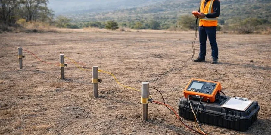
The resistivity rig itself is deceptively simple—a portable console, four stainless steel electrodes, and cables spooled across the ground—but the real challenge in Torrance is coupling. The city sits on a mosaic of urban fill, old asphalt patches, and naturally resistive dune sands along the western edge near the beach cities. When we set up a Schlumberger array on dry, compacted fill along Hawthorne Boulevard, getting electrode contact resistance down to acceptable levels can eat up thirty minutes if we don't pre-soak the ground. The ASTM D6431 guide is clear on this: contact resistance above 2,000 ohms introduces noise that mimics false layering. We carry bentonite slurry and saline solution specifically for these tough spots. Another risk factor is cultural noise—power lines feeding the Torrance refinery complex and the 405 freeway corridor induce stray currents that can corrupt data if the stacking time is too short. Our team runs extended acquisition cycles and post-processes with notch filters to clean up 60 Hz interference. Skipping these local calibration steps leads to inverted models that look plausible but are geologically nonsense—an expensive mistake when a contractor relies on them for dewatering estimates.
Our services
Our electrical resistivity program in Torrance covers everything from rapid reconnaissance to detailed anomaly mapping. Here's what we typically deploy for South Bay projects:
1D Vertical Electrical Sounding (VES)
A single-point depth investigation using expanding electrode spacing (Schlumberger array). We use this to pin down the depth to the water table, identify the contact between fill and natural ground, or locate the top of the bedrock surface where the Palos Verdes Sandstone underlies the younger sediments. Each sounding produces a resistivity-depth curve that we invert into a layered geoelectric model.
2D Resistivity Imaging (ERT)
A multi-electrode profiling method that builds a continuous cross-section of subsurface resistivity. Perfect for linear features—pipeline alignments, road cuts, or property boundary investigations. In Torrance's industrial zones, we've used ERT to map abandoned underground storage tanks and differentiate clean fill from hydrocarbon-impacted zones.
Groundwater and Saltwater Intrusion Mapping
The coastal aquifers beneath Torrance are subject to saltwater intrusion from Santa Monica Bay. Resistivity is highly sensitive to pore-fluid salinity—a drop from 50 ohm-m to 5 ohm-m often signals the freshwater-saltwater interface. We run coastal transects to help water management agencies and well owners track the wedge position over time.
Common questions
What depth can a VES survey reach in Torrance's geology?
It depends entirely on the electrode spread. With a maximum current electrode spacing (AB/2) of 300 feet, we can reliably image to about 100 to 120 feet depth in typical South Bay sediments. The limiting factor here is often the shallow water table in the coastal plain—once you hit saturated material, the current flows laterally and depth penetration plateaus. For deeper targets beyond 150 feet, we usually recommend combining resistivity with seismic refraction or MASW to constrain the interpretation with independent velocity data.
How much does an electrical resistivity survey cost in Torrance?
For a single VES sounding with full data processing and a geophysical report, budget between US$720 and US$1,040. A 2D resistivity line covering 500 to 800 linear feet typically runs higher due to the cable setup and processing time. The final number depends on site access conditions, electrode array configuration, and whether we need to include GPS surveying for precise electrode positions. We always provide a fixed-price proposal after a site walk.
Can resistivity surveys work on paved surfaces or inside buildings?
Direct electrode contact with the ground is essential, so asphalt or concrete pavement stops conventional resistivity dead in its tracks. On paved sites, we can sometimes work from the edges of the hardstand, or we'll core small holes through pavement for electrode placement if the client permits. Inside buildings, resistivity isn't practical—the rebar in the slab and electrical infrastructure create too much noise. For those scenarios, we recommend a different geophysical method like GPR or seismic techniques that couple through hard surfaces more effectively.